Monday, 27 July 2026, 23:47
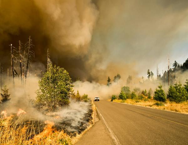
An evacuation order was issued Tuesday afternoon for a wildfire near Covelo in Mendocino County, prompting residents to leave immediately. The Mendocino County Sheriff's Office announced the order just before 4 p.m., urging residents not to delay. The fire, dubbed the Agency Fire, was reported about 3:30 p.m. Tuesday near the 24000 block of Agency Road.
According to Watch Duty reporter Danilla Sands, the fire was first reported by Miranda Schwegler, a regional captain for Watch Duty, at 3:33 p.m. Schwegler described the vegetation fire as burning in light, flashy fuels at a moderate rate of speed. The fire size was initially estimated at 15 acres, but by about 4:10 p.m., local officials downgraded the blaze, estimating it at three-quarters of an acre, according to the Watch Duty App. Evacuations have been ordered for areas east of Mina Road, with Mina Road serving as the egress route to Highway 162 into Covelo. The evacuation order was issued for zone MEN-1COV14-A and a warning for zone MEN-1COV14-B, according to a county evacuation map. Resources are on the scene, and fire crews are working to contain the blaze. Forward progress of the fire was stopped around 5:20 p.m., according to Capt. Quincy Cromer, a spokesperson for the Mendocino County Sheriff’s Office. The evacuation order and warning stayed in place for several hours after forward progress was stopped while firefighters continued their work. The order was lifted shortly after 7 p.m. Tuesday. It was unclear Wednesday morning whether any structures had been damaged during the fire.
The evacuation notices were made shortly before 4:20 p.m. and covered the fire area east of Mina Road to Agency Road. Residents under the evacuation order were told to leave immediately and not delay, according to an alert from the Sheriff’s Office. Authorities urged people to use the safest route available, check on neighbors if they had time and avoid blocking roads so emergency crews could reach the fire. The recommended evacuation route for residents east of Mina Road is Mina Road to Highway 162 into Covelo, according to police. The Mendocino County Sheriff’s Office issued the evacuation notice through a Wireless Emergency Alert, advising residents to call 911 only for emergencies. Officials said more information, including evacuation zone maps and updates, would be posted as it becomes available at mendoready.org.
Covelo is a small community in Mendocino County, located within the Round Valley Indian Reservation. The area is known for its rural character and susceptibility to wildfires, especially during dry summer months. The Agency Fire threatens local homes and infrastructure, with emergency services coordinating evacuation routes and response efforts.
Mendocino County has a history of significant wildfires, including the 2018 Mendocino Complex Fire, which burned over 459,000 acres and became one of the largest in California history. The region's fire-prone conditions are exacerbated by drought and climate change, making early detection and rapid response critical.
Evacuation planning is a growing challenge across California and the US as wildfires become faster and more ferocious due to climate change. A recent UC Santa Barbara study found that 2.5 million people in the US live in small towns at high risk for wildfire but with limited escape routes, and fire fatalities are concentrated in such communities. Nearly 18 million more reside in places with lower but growing wildfire threat and sometimes only one way out. In California, communities like Fairfax and Kentfield in Marin County face similar evacuation chokepoints. A 2025 evacuation study for Berkeley concluded that during a major wildfire, it could take up to four hours to evacuate over 20,000 residents from hillside neighborhoods, requiring hundreds of buses and ambulances. These findings underscore the importance of advance planning and rapid response, as even meticulously crafted plans can be overwhelmed by the speed and intensity of modern wildfires.
In related fire preparedness efforts, a training burn is scheduled for July 11, 2026, at the Ukiah Municipal Airport, conducted by the Ukiah Valley Fire Authority (UVFA). This live-fire exercise will start at 8:30 a.m. and is part of annual preparations for peak fire season, reducing available fuels and providing valuable training. Residents may see smoke across the valley. Additionally, the UVFA has a fuels reduction crew formed after a 2024 grant, which has treated at least 500 acres in areas including Ukiah, Willits, Laytonville, and Covelo. The crew focuses on fuel mitigation but is cross-trained to respond to fires. Their work includes the Western Hills of Ukiah, Russian River Estates, the Great Redwood Trail, the Ukiah Municipal Airport property, and collaboration with Cal Fire. The grant runs through December 2028, and the goal is to find long-term funding to continue this asset.
Residents in the affected area should follow evacuation orders and stay informed through local authorities. The situation remains dynamic, and updates will be provided as more information becomes available. For real-time alerts, residents are encouraged to use Watch Duty and monitor the Mendocino County Sheriff's Office communications.